Navigation is something that we probably all miss from our tracking software, especially if we go out and run/hike/bike at foreign places, and thus want to stick to a predefined route. RunKeeper's support for routes could be considered as a very basic feature in that direction, but it has some flaws, as I pointed out in my previous post. As we were talking about this, one my friend suggested me to have a look at the OsmAnd (OSM (OpenStreetMap) Automated Navigation and Directions), and this post summarizes my first impressions.
First
of all, I have to clarify, that OsmAnd is not a tracking software
with an extension for navigation. As its name suggests, it is a
software for navigation that has integrated tracking to its features
too. This means, that in a way, I was trying to use the software in a
non-standard way, which can also be a contributor to some of my
discomforts.
The
Map
Obviously, the app uses OpenStreetmap,
and the user can manage which databases to download to the device.
This means a big plus, as the map works just perfectly fine when
offline. Note, that the free version is limited to 10 maps, but I
would be surprised if that would not be enough for most of the users.
The
interface
The
UI is of course optimized for navigation purposes. You can set the
destination, waypoints, search for POIs, show previous tracks on the
map, etc. Personally, I am not very fond of this layout. I didn't find it neither consequent nor intuitive,
where to find something, although there are usually several different
ways to do the same. This may be a PEBKAC situation, but my opinion
is still that the UI is a bit chaotic, but not that much, that it
could not be tolerated.
Navigation
There
is not much to say about this. It works as it should. The audio cues
are perfectly understandable (at least in English), route calculation
is fast. However, I had two problems:
-
Even if I set that I'm on foot, the directions consider one-way-streets as they are. Although it could be due to the quality of the Moroccan map.
-
I couldn't figure out how to check a waypoint. I guess it should be automatic, but it was not the case, and I could not figure out how to manually delete after reaching it. Thus the app always wanted to direct me back to the waypoint. (Again, possible PEBKAC situation here, if somebody can enlighten me, please do so in the comment section.)
Tracking
For
us, this is the dealbreaker feature. There are several promising
things, but my overall experience is not too shiny:
-
Starting and stopping a track is not very straight forward, but on the other hand, the distance so far, the estimated time of arrival, the altitude, the destination altitude is indicated in the corner of the screen. (And it is fully configurable.)
-
You can take photos and videos, which will be saved with coordinates, however, they will not strictly be attached to the track itself.
-
When the track is started, it is possible to set the frequency of sampling from continuous up to 5 minutes. This can be rather useful when someone wants to save battery life, and mostly travels on roads. Though I don't know if the app takes an additional measurement or not, when the accelerometer has unusual values, i.e., turning at a crossing. Anyhow, I always tried continuous or 5 second frequency.
-
In the settings there is a “snap to roads” option for navigation that can be set independently for different activities (walking/biking/driving). I was really happy to see this, as I thought, that it will snap my gps track to roads as well, which would be a very nice option together with the 5-10 sec sampling. Especially for biking and for tracks below high buildings where the quality of the gps signal is terrible. But unfortunately, corrections on the gps position only apply for navigation purposes, not the track itself.
-
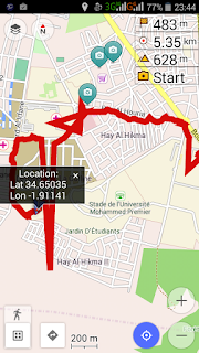
Last but not least, the quality of the track is often terrible, as the third screenshot shows it below. I'd assume, that a simple outlier filter could have been implemented to ignore the really bad measurements. But unfortunately this is not the case.
Syncing
The
only possible way for syncing now is to save the GPX file to Dropbox
or send in e-mail. So no specific connection to RunKeeper, Strava,
Endomondo, or other apps databases, but maybe the process can be made
automatic using Dropbox in combination with Tapirik or FitnessSyncer.
Overall
opinion
To be honest, I don't suggest using OsmAnd for tracking yet, but the app has some original features and ideas, so I hope,
that the development of it will progress in this direction too. I'll
definitely check on it again after a while. Let me know in the
comments if You have a different opinion or if I missed
something.


